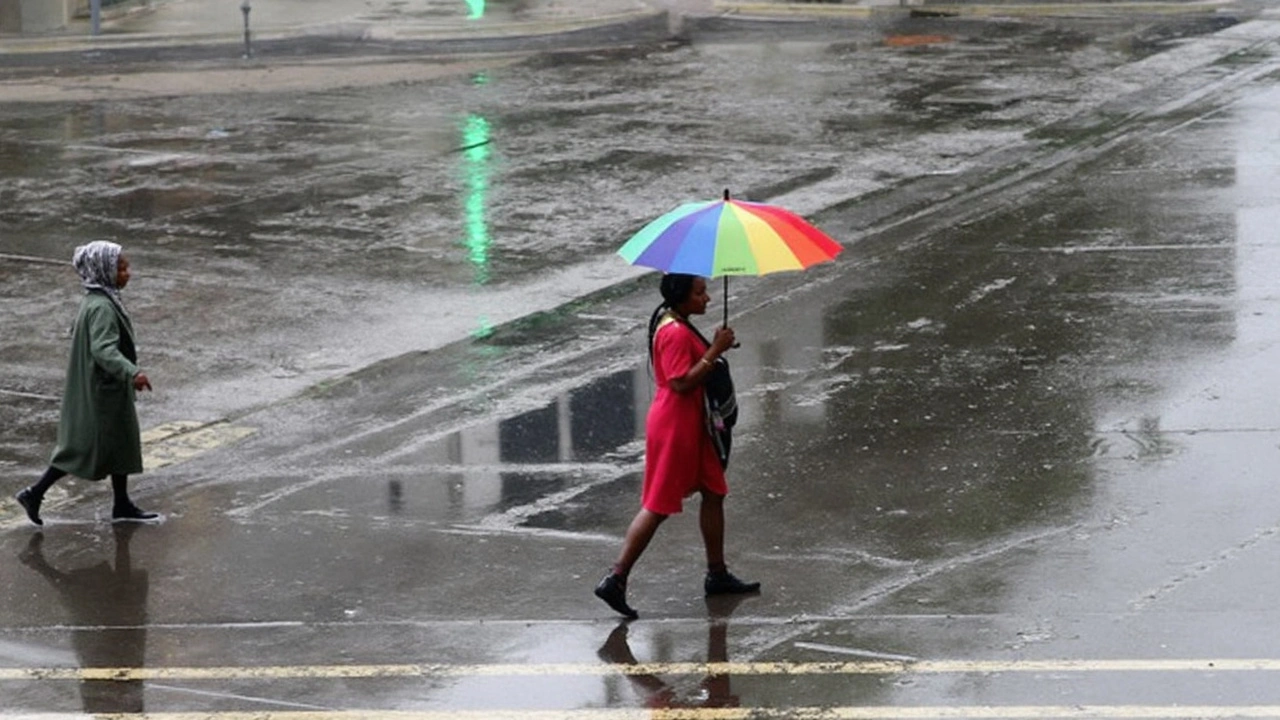

Relentless Rainfall Puts South Africa on Flood Watch
South Africa isn’t just getting a little wet—it’s bracing for a drenching that could shake up daily life for millions. The South African Weather Service (SAWS) isn’t mincing words this week. They’ve rolled out a series of severe weather warnings for much of the country between 5 and 8 January 2025. The scope is wide: from Gauteng’s urban nerve center to the coastlines of KwaZulu-Natal (KZN) and deep into rural Limpopo and the Free State. The warnings come as rainfall totals are expected to reach a hefty 50–70 millimeters across these regions. For comparison, that’s more rain in a few days than some towns see in an entire month.
Here’s where things get intense: SAWS has issued an Orange Level 8 warning for the KZN coastal belt. This isn’t just a splash in the street—officials are warning of widespread flooding, serious property damage, and the real possibility of roads and bridges getting washed away. Some municipal services, like water and electricity, could grind to a halt if infrastructure takes a hit. Coastal towns are on edge, with authorities already planning emergency responses for affected communities.
The heart of KZN won’t escape unscathed, either. Most of the province sits under an Orange Level 6 alert, where previous storms have already tested basic infrastructure. The threat of mud-based homes collapsing or being swept away is all too real, and the fate of makeshift informal settlements looks even bleaker. Orange Level 5 warnings push inland to cover Gauteng, Mpumalanga, parts of Limpopo, and the Free State. The risks here run from flooded streets and gridlocked traffic to dangerous, fast-moving streams that can upend cars or surprise unwary pedestrians in seconds.
Think it ends there? Not a chance. Eastern Free State, North West, Eastern Cape, and more of Limpopo and Mpumalanga are on Yellow Level 2 alert. These areas might escape the most catastrophic flooding, but issues like localized road closures and damage to homes and businesses remain very much on the cards. Every low-lying area is a potential danger zone. The only thing that’s certain is that life for residents across these provinces is about to get a whole lot messier—and potentially riskier—over the coming days.
Streets, Services, and Shelter: Preparing for the Worst
For most people in these regions, the threat isn’t just about getting wet. Flooded streets mean blocked commutes, stranded motorists, and cut-off communities. SAWS is urging motorists not to take chances on swollen roads, which will only get slipperier as the weather worsens. Flash floods can come out of nowhere, especially in city suburbs where drainage is already stretched thin. Pedestrians are being told to stay put if possible, as even shallow-looking water can hide dangerous currents.
Emergency services, meanwhile, are bracing for busy days ahead. With warnings about rivers rising and the very real risk of tornadoes—yes, tornadoes—popping up in some regions, municipalities are under pressure to deliver rapid answers. Mpho Rasimphi, a familiar face for those who follow weather news on SABC, has been vocal: be ready. This round of storms comes after a string of heat alerts and disruptive rainfall warnings that have kept communities on edge since December. For many, the upcoming days will test disaster plans to their limits.
It’s not just about immediate impact; there’s a ripple effect when major weather moves in. Schools could close, power outages may stretch for hours or days, and the scramble for shelter will become urgent. Health clinics worry about patients who can’t reach them, and local businesses are already sandbagging storefronts ahead of the worst. City officials stress the importance of listening to official updates—mobile networks and local radio will be key as conditions change hour-by-hour.
People across South Africa’s central and eastern provinces are watching the skies—and the news. For now, the best anyone can do: prepare, stay informed, and treat every patch of water with caution. When the weather turns this extreme, even familiar streets and landmarks can turn treacherous, fast.


20 Comments
Stay safe during the heavy rains; keep emergency kits ready and avoid low‑lying routes.
Wow, those rain numbers are insane! 😮 Make sure you grab sandbags and keep your phone charged – you never know when the power might flicker.
Oh great, just what we needed – another excuse for the city to turn our streets into rivers of disappointment.
Typical, the system can’t handle a bit of water.
When you look at the pattern of climate extremes across the Southern Hemisphere, you see a clear acceleration of risk that cannot be dismissed as a mere anomaly. The South African Weather Service’s tiered alert system is a commendable attempt to communicate urgency, yet the public’s response hinges on infrastructure resilience that has historically lagged. Floodplain zoning policies, for instance, have often been undermined by rapid urban expansion, especially around Gauteng’s suburbs where informal settlements proliferate. This neglect creates a perilous feedback loop: more people move into vulnerable areas, then the next storm exposes the fragility of that choice. Moreover, the economic cost of repeated flood damage erodes municipal budgets, limiting the ability to upgrade drainage networks or reinforce bridges. As we examine the rainfall totals of 50‑70 mm over a few days, we must ask how such volumes compare to historical averages and whether the basins can absorb the surge without overflow. The answer, regrettably, points to insufficient catchment capacity, exacerbated by deforestation in upstream catchments. Adding to the complexity, climate models predict that Southern Africa will experience more frequent heavy precipitation events due to shifting jet streams. Therefore, emergency preparedness must evolve from reactive sandbagging to proactive land‑use planning. Communities should be encouraged to develop localized early‑warning systems that leverage mobile networks, as the national broadcasts may not reach every remote village in time. Public education campaigns must stress that “just a little water” can become a deadly current within seconds, especially in shallow streams that appear harmless. Infrastructure engineers ought to prioritize modular bridge designs that can be quickly repaired or replaced after flood damage. In the longer term, investment in green infrastructure-wetlands restoration, riparian buffers-offers a natural mitigation strategy that complements hard engineering solutions. It is also vital that the government incentivizes insurance schemes that reflect true flood risk, thereby encouraging property owners to adopt protective measures. Finally, the social dimension cannot be ignored: marginalized communities often bear the brunt of such disasters, and equitable aid distribution is essential to prevent a widening of socioeconomic gaps. In sum, while the immediate weather threat is alarming, the underlying systemic issues demand sustained attention and coordinated action across all levels of governance.
Sure, you can string together a dissertation, but the average resident needs actionable tips, not a lecture on policy jargon.
Behold! The heavens have opened, and our feeble mortal streets shall be swallowed whole - let the city brace for its inevitable tempest!
It’s worth noting that many rural clinics have backup generators, but fuel supplies can run low quickly, so pre‑arranging local fuel caches could be lifesaving.
Invest in proper drainage systems you will thank yourself later
While everyone panics about the rain, one could argue that the real crisis is our complacent attitude toward climate negligence.
Hold onto your hats!!! The flood warnings are not a suggestion – they are an imminent reality that could reshape entire neighborhoods!!!
Oh sure, because building a sandbag wall is what you do when the river threatens to drown your house.
Let’s pool resources, share sandbags across neighborhoods, and ensure everyone, especially the most vulnerable, has a safe place to go.
We must mobilize community volunteers, coordinate with local authorities, and execute a swift response plan to safeguard lives.
Floods know no borders; we should learn from global best practices and adapt them here now, before another tragedy strikes.
Stay hopeful, stay prepared 😊 together we’ll get through this.
Recognizing the multifaceted impact of prolonged inundation requires us to consider not only hydraulic engineering constraints but also the psychosocial stressors imposed on affected populations; the disruption to supply chains, healthcare delivery, and educational continuity forms an interlinked web of challenges that demand a coordinated, interdisciplinary response strategy, leveraging both public sector resources and private sector agility.
It’s disheartening to see preventable suffering when authorities have warned for weeks.
My thoughts are with anyone whose home is impacted – please stay safe and reach out if you need help 🙂
Remember that resilience is built one caring act at a time